Researchers
Praveen Edara
Carlos Sun
Henry Brown
About the research
In support of its Toward Zero Deaths (TZD) initiative, the Missouri Department of Transportation (MoDOT) initiated this research project to develop guidance on treatments that can reduce crashes and fatalities. The first task for this project was to synthesize the literature and state of the practice related to system-wide safety treatments and document the treatments’ effectiveness. In particular, the objective was to examine those treatments that have not already been implemented in Missouri. The safety effectiveness, implementation guidelines, limitations, costs, and concerns of the treatments were documented. The identified safety treatments work in conjunction with the “Necessary Nine” strategies identified in the Missouri Blueprint. Accordingly, the synthesis covered three areas: (1) horizontal curves, (2) intersections, and (3) wrong-way crashes. The reviewed treatments included signing, geometric design and access management, intelligent transportation systems (ITS), pavement markings, and signal control enhancements to improve safety. In the last few years, MoDOT has replaced several high-crash intersections on rural highways in the state with J-turns. Given their safety effectiveness and low cost, J-turns have become a preferred alternative to replace high-crash two-way stop-controlled intersections on high-speed highways. Unfortunately, national guidance on the design of J-turns is very limited. This project addressed this gap in practice by developing guidance on spacing and acceleration lanes. A thorough examination of crashes that occurred at 12 existing J-turn sites in Missouri was conducted. The crash review revealed the proportions of five crash types occurring at J-turn sites: (1) major road sideswipe (31.6%), (2) major road rear-end (28.1%), (3) minor road rear-end (15.8%), (4) loss of control (14%), and (5) merging from U-turn (10.5%). The crash rates for both sideswipe and rear-end crashes decreased with an increase in the spacing from the minor road to the U-turn; J-turns with a spacing of 1,500 ft or greater experienced the lowest crash rates. A calibrated simulation model was used to study various volume scenarios and design variables. For all scenarios, the presence of an acceleration lane resulted in significantly fewer conflicts. Therefore, acceleration lanes are recommended for all J-turn designs, including lower volume sites. Moreover, while a spacing between 1,000 and 2,000 ft was found to be sufficient for low-volume combinations, a spacing of 2,000 ft is recommended for medium- to high-volume conditions.
Funding Sources:
Midwest Transportation Center
Missouri Department of Transportation ($80,091.00)
University of Missouri – Columbia ($63,232.00)
USDOT/OST-R ($80,278.00)
Total: $223,601.00
Contract Number: DTRT13-G-UTC37
Researchers
Carlos Sun
Praveen Edara
Henry Brown
Charles Nemmers
About the research
The American Association of State Highway Transportation Officials (AASHTO) released a supplement to the Highway Safety Manual (HSM) in 2014 that included models for freeway interchanges composed of segments, speed-change lanes, and terminals. A necessary component when using the HSM is having the appropriate safety-related data. However, a high percentage, approximately 75 percent, of interchange crashes in the Missouri Department of Transportation (MoDOT) Transportation Management System (TMS) are landed on an incorrect location within an interchange. For example, crashes are frequently assigned to the midpoint of the ramp terminal instead of to one of the two ramp terminals. Another example includes crashes that are assigned to the freeway mainline when the crashes are related to the ramps. In order to properly calibrate and use HSM freeway interchange models, the location of crashes needs to be corrected. Crash landing correction involves the visual inspection of crash images compiled by the Missouri State Highway Patrol. A detailed procedure was established along with a reviewer test so that crash correction can be conducted uniformly among multiple reviewers. A total of 10,897 crashes were reviewed and 9,168 underwent detailed review and correction. Among the total crashes reviewed, 1,482 were partial cloverleaf crashes, 5,086 diamond interchange crashes, 780 ramp crashes, and 1,820 speed-change lane crashes. The crash location correction process helped to eliminate the error rate associated with interchange crash locations by 69 percent. Any analyst can correct crash locations by following the procedure detailed in the final report for this project.
Funding Sources:
Midwest Transportation Center
Missouri Department of Transportation ($59,996.00)
University of Missouri – Columbia ($36,278.00)
USDOT/OST-R ($92,698.00)
Total: $188,972.00
Contract Number: DTRT13-G-UTC37
Researchers
Charles Nemmers
About the research
This report synthesizes the safety corridor programs of 13 states that currently have some type of program: Alaska, California, Florida, Kentucky, Minnesota, New Jersey, New Mexico, New York, Ohio, Oregon, Pennsylvania, Virginia, and Washington. This synthesis can help Midwestern states implement their own safety corridor programs and select pilot corridors or enhance existing corridors. Survey and interview information about the states? programs was gathered from members of each state department of transportation (DOT) and Federal Highway Administration (FHWA) division office.
Topics discussed included definitions of a safety corridor; length and number of corridors in the program; criteria for selection of a corridor; measures of effectiveness of an implemented safety corridor; organizational structure of the program; funding and legislation issues; and engineering, education, enforcement, and emergency medical service strategies. Safety corridor programs with successful results were then examined in more detail, and field visits were made to Kansas, Oregon, Pennsylvania, and Washington for first-hand observations.
With the survey and field visit information, several characteristics of successful safety corridor programs were identified, including multidisciplinary (3E and 4E) efforts; selection, evaluation, and decommissioning strategies; organization structure, champions, and funding; task forces and Corridor Safety Action Plans; road safety audits; and legislation and other safety issues. Based on the synthesis, the report makes recommendations for establishing and maintaining a successful safety corridor program.
Funding Sources:
Midwest Transportation Consortium
University of Missouri – Columbia
Project Details
05/01/07
07/31/08
Midwest Transportation Consortium
Missouri Department of Transportation
University of Missouri - Columbia
Researchers
Glenn Washer
Brent Rosenblad
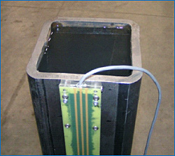
About the research
- Develop an instrumented pile capable of monitoring the thermal and seismic behavior at a bridge foundation
- Deploy an instrumented pile under simulated field conditions
- Assess the effectiveness of the remote monitoring system for asset management
Abstract
A key challenge to managing fixed assets such as bridges and other transportation infrastructure is monitoring their condition over time. Under typical service conditions, deterioration resulting from traffic loading and difficult environmental conditions can result in a reduction or loss of service of a particular asset, or even life threatening and dangerous failures. Extreme events such as earthquakes and floods present a still greater challenge in that the service condition of the asset may change abruptly and without warning, leaving managers without key information they need to respond to the event. The goal of this project is to develop remote health monitoring technology that will provide managers and owners with timely information on the condition of civil infrastructure assets. This will be achieved through the development of an instrumented pile that will provide real-time data on bridge scour and seismic activity, allowing for the remote monitoring of bridge conditions by key managers and engineers.
Potential Benefits of the Project:
- Enable widespread remote monitoring of more than 26,000 scour critical bridges in the U.S.
- Provide foundation for remote health monitoring systems for culverts, tunnels and highway bridges in general
Funding Sources:
Midwest Transportation Consortium
Missouri Department of Transportation
University of Missouri – Columbia
Researchers
J. Erik Loehr
About the research
Asset Management principles and systems share common goals and objectives with Load and Resistance Factor Design (LRFD) techniques. Asset management seeks to facilitate cost-effective maintenance, upgrade, and operation of physical assets in a systematic way. LRFD methods seek to produce cost-effective design decisions based on rational evaluation of performance, rather than judgment and experience of individual designers. Despite similar goals and objectives, there has to date been no attempt to integrate, or even relate, these techniques and they remain as essentially independent approaches. The project proposed here seeks to integrate the techniques specifically for the design and management of earth slopes and earth retention. Potential Benefits of the Project Potential to extend to other applications such as pavements, bridges, tunnels, and other applications where both asset management and LRFD techniques are currently utilized.
Funding Sources:
Midwest Transportation Consortium
University of Missouri – Columbia
Researchers
Sam Kiger
About the research
- Develop risk assessment procedures to identify critical bridges in a bridge network
- Develop bridge vulnerability assessment guide
- Develop concepts for mitigation and structural protection of bridges
Soon after the attacks of September 11, 2001, the Federal Highway Administration (FHWA) and the American Association of State Highway and Transportation Officials (AASHTO) assembled a Blue-Ribbon Panel of experts to develop strategies and provide guidance to improve the safety and security of bridge and tunnel infrastructure. This effort led to recognizing that the threat is real and can be devastating, risk assessment is necessary, and engineering guidance are needed based on research. Building on current and past efforts, the goal of this project is develop procedures to assist professionals and bridge owners identify critical bridges and to develop procedures to assess their vulnerability to explosions (terrorist’s bomb attacks). Potential Benefits of the Project The procedures and design guides developed in this project will benefit the bridge owners, designers, inspectors, and professionals nationwide.
Funding Sources:
California Department of Transportation
Midwest Transportation Consortium
University of Missouri – Columbia
Researchers
Kathleen Trauth
Thomas Johnson
About the research
The purpose of the project was to develop useable techniques to integrate a broader range of potential impacts of transportation investments into transportation planning and decision-making. The research project described in this report developed a multi-attribute framework that can be used to assist in organizing and synthesizing information to measure costs and benefits, both monetary and non-monetary, of highway corridor investments.
A modular approach was taken to developing individual techniques to quantify the potential impacts that could be utilized within the framework. The framework is flexible enough to accommodate the incorporation of additional techniques over time. To determine the range of potential impacts to consider, the values and needs of various stakeholders in highway corridors were taken into account and incorporated into variables, or indicators, to be used in a comprehensive system for evaluating impacts, costs, and benefits.
Example techniques include a consideration and demonstration of the utility of geographic information systems (GIS) to organize data for use with the hedonic land valuation method. A prediction map was generated from this process, indicating the price consumers are willing to pay for a house in relation to its location with respect to highway corridors. This information is useful in analyzing the impact of competing corridor alternatives.
In order to measure other indicators, the project also assessed the utility of highresolution satellite remote sensing (RS) image data to provide highly accurate inputs necessary for economic models and as a means of measuring success after investments have been made. A methodology was developed to identify commercial and industrial origins and destinations from impervious surfaces. This, in turn, was translated into a calculation of average travel distances that could be used to quantify accessibility impacts associated with corridor alternatives.
Remote sensing and GIS were assessed because of the spatial nature of transportation investments and their potential as a measuring tool for the transportation indicators. This multi-attribute framework is consistent with the Missouri Department of Transportation?s (MoDOT?s) overall planning direction of including the perspectives of more individuals/groups and potential impacts in decision making. This overall planning direction is seen in the Planning Framework and the Long-Range Transportation Plan (LRTP).
Funding Sources:
U.S. Department of Transportation
University of Missouri – Columbia