Researchers
Ed Jaselskis
About the research
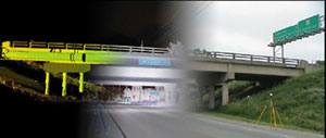
Laser scanning is a terrestrial laser-imaging system that creates highly accurate three-dimensional images of objects for use in standard computer-aided design software packages. This report describes results of a pilot study to investigate the use of laser scanning for transportation applications in Iowa. After an initial training period on the use of the scanner and Cyclone software, pilot tests were performed on the following projects: intersection and railroad bridge for training purposes; section of highway to determine elevation accuracy and pair of bridges to determine level of detail that can be captured; new concrete pavement to determine smoothness; bridge beams to determine camber for deck-loading calculations; stockpile to determine volume; and borrow pit to determine volume. Results show that it is possible to obtain 2?6 mm precision with the laser scanner as claimed by the manufacturer compared to approximately one-inch precision with aerial photogrammetry using a helicopter. A cost comparison between helicopter photogrammetry and laser scanning showed that laser scanning was approximately 30 percent higher in cost depending on assumptions. Laser scanning can become more competitive to helicopter photogrammetry by elevating the scanner on a boom truck and capturing both sides of a divided roadway at the same time. Two- and three-dimensional drawings were created in MicroStation for one of the scanned highway bridges. It was demonstrated that it is possible to create such drawings within the accuracy of this technology. It was discovered that a significant amount of time is necessary to convert point cloud images into drawings. As this technology matures, this task should become less time consuming.It appears that laser scanning technology does indeed have a place in the Iowa Department of Transportation design and construction toolbox. Based on results from this study, laser scanning can be used cost effectively for preliminary surveys to develop TIN meshes of roadway surfaces. It also appears that this technique can be used quite effectively to measure bridge beam camber in a safer and quicker fashion compared to conventional approaches. Volume calculations are also possible using laser scanning. It seems that measuring quantities of rock could be an area where this technology would be quite beneficial since accuracy is more important with this material compared to soil. Other applications for laser scanning could include developing as-built drawings of historical structures such as the bridges of Madison County. This technology could also be useful where safety is a concern such as accurately measuring the surface of a highway active with traffic or scanning the underside of a bridge damaged by a truck. It is recommended that the Iowa Department of Transportation initially rent the scanner when it is needed and purchase the software. With time, it may be cost justifiable to purchase the scanner as well. Laser scanning consultants can be hired as well but at a higher cost.
Funding Sources:
Iowa Department of Transportation ($22,745.00)
Midwest Transportation Consortium
Total: $22,745.00