Project Details
06/01/09
05/31/10
University of Northern Iowa
Researchers
Shashi Nambisan
Michele Regenold
About the research
This project will encourage teens to develop their science, technology, engineering, and math (STEM) skills in relation to transportation. It will do this by helping grow Go!, a free online magazine for teens published by Iowa State University since 2007. Published six times per school year, Go! Will explicitly incorporate STEM content in three to four articles and one hands-on, STEM-related activity per issue.
Researchers
Tim Strauss
About the research
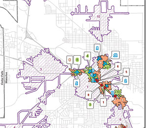
This project analyzes the characteristics and spatial distributions of motor vehicle crash types in order to evaluate the degree and scale of their spatial clustering. Crashes occur as the result of a variety of vehicle, roadway, and human factors and thus vary in their clustering behavior. Clustering can occur at a variety of scales, from the intersection level, to the corridor level, to the area level. Conversely, other crash types are less linked to geographic factors and are more spatially ?random.? The degree and scale of clustering have implications for the use of strategies to promote transportation safety.
In this project, Iowa’s crash database, geographic information systems, and recent advances in spatial statistics methodologies and software tools were used to analyze the degree and spatial scale of clustering for several crash types within the counties of the Iowa Northland Regional Council of Governments. A statistical measure called the K function was used to analyze the clustering behavior of crashes. Several methodological issues, related to the application of this spatial statistical technique in the context of motor vehicle crashes on a road network, were identified and addressed. These methods facilitated the identification of crash clusters at appropriate scales of analysis for each crash type. This clustering information is useful for improving transportation safety through focused countermeasures directly linked to crash causes and the spatial extent of identified problem locations, as well as through the identification of less location-based crash types better suited to non-spatial countermeasures.
The results of the K function analysis point to the usefulness of the procedure in identifying the degree and scale at which crashes cluster, or do not cluster, relative to each other. Moreover, for many individual crash types, different patterns and processes and potentially different countermeasures appeared at different scales of analysis. This finding highlights the importance of scale considerations in problem identification and countermeasure formulation.
Funding Sources:
Iowa Department of Transportation
Midwest Transportation Consortium
University of Northern Iowa
Researchers
Ramanathan Sugumaran
Chris Fulcher
Tim Strauss
Md. Salim
About the research
Winter maintenance, particularly snow removal and the stress of snow removal materials on public structures, is an enormous budgetary burden on municipalities and nongovernmental maintenance organizations in cold climates. Lately, geo-spatial technologies such as remote sensing, geographical information systems (GIS), and decision support tools are providing valuable assistance in planning snow removal operations. A few researchers recently used geo-spatial technologies for the development of winter maintenance tools. However, most of these winter maintenance tools, while having the potential to address some of the informational needs of snow removal agencies, are not typically placed in the hands of planners and other interested stakeholders. Most tools are not constructed with a nontechnical user in mind and lack an easy-to-use, easily understood interface.
A major goal of the project was to implement a web-based Winter Maintenance Decision Support System (WMDSS) for planning snow removal operations that enhances the capacity of stakeholders (city/county planners, resource managers, transportation personnel, citizens, and policy makers) to evaluate different procedures to manage snow removal assets optimally. This goal was accomplished by integrating geo-spatial analytical techniques (GIS and remote sensing), existing snow removal asset management systems (SRAMS), and web-based spatial decision support systems. In order to extract up-to-date transportation infrastructure features, this study used hyperspectral imagery from the high-resolution Airborne Visible/Infrared Imaging Spectrometer (AVIRIS). Classifiers such as the Spectral Angle Mapper (SAM), Mixture-tuned Matched Filtering (MTMF) and Mixture-Tuned Matched Filtering combined with Classification and Regression Tree (MTMF-CART) were used to extract the transportation infrastructures. The study found that the MTMF classification method produced the best overall results compared to both the SAM classifier and MTMF-CART methods, and the overall accuracies for the three classifications were 81.89%, 88.92%, and 84.32%, respectively. The web-based decision support system was implemented using the ESRI ArcIMS ActiveX Connector and related web technologies like ASP, JavaScript, HTML, and XML. The expert knowledge is represented as business rules using Visual Rule Studio, and is integrated with the system. The developed system not only manages and allocates resources, but also provides expert advice to assist complex decision making such as routing, optimal resource allocation, and live weather information monitoring. This system was developed in collaboration with Black Hawk County; the City of Columbia, MO; the Iowa DOT; and the cities of Cedar Falls, IA and Waterloo, IA. Demonstration versions of this product were also given to these agencies in order to improve the usability and applicability of the system.
Funding Sources:
Iowa Department of Transportation
U.S. Department of Transportation
University of Northern Iowa