Researchers
Carlos Sun
About the research
Secondary accident statistics can be useful for studying the impact of traffic incident management strategies. An easy-to-implement methodology is presented for classifying secondary accidents using data fusion of a police accident database with intranet incident reports. A current method for classifying secondary accidents uses a static threshold that represents the spatial and temporal region of influence of the primary accident, such as two miles and one hour. An accident is considered secondary if it occurs upstream from the primary accident and is within the duration and queue of the primary accident. However, using the static threshold may result in both false positives and negatives because accident queues are constantly varying.
The methodology presented in this report seeks to improve upon this existing method by making the threshold dynamic. An incident progression curve is used to mark the end of the queue throughout the entire incident. Four steps in the development of incident progression curves are described. Step one is the processing of intranet incident reports. Step two is the filling in of incomplete incident reports. Step three is the nonlinear regression of incident progression curves. Step four is the merging of individual incident progression curves into one master curve. To illustrate this methodology, 5,514 accidents from Missouri freeways were analyzed. The results show that secondary accidents identified by dynamic versus static thresholds can differ by more than 30%.
Funding Sources:
Midwest Transportation Consortium ($39,217.00)
Total: $39,217.00
Researchers
James Noble
Charles Nemmers
Wooseung Jang
Cerry M. Klein
About the research
Winter road maintenance operations require many complex strategic and operational planning decisions. The five primary problems involved in this intricate planning procedure include locating depots, designing sectors, routing service vehicles, scheduling vehicles, and configuring the vehicle fleet. The complexity involved in each of these decisions has resulted mainly in research that approaches each of the problems separately and sequentially, which can lead to isolated and suboptimal solutions. After discussing the complexity of the relaxed subproblems that would need to be solved to optimize the intricate winter maintenance operations, the research turns to a heuristic approach to more feasibly address the interrelated problems.
This report subsequently presents a systematic, heuristic-based optimization approach to integrate the winter road maintenance planning decisions for depot location, sector design, vehicle route design, vehicle scheduling, and fleet configuration. The approach presented is illustrated through an example of public sector winter road maintenance planning for a rural transportation network in Boone County, Missouri.
When applied to the real-world winter road maintenance planning problems for Boone County, the methodology delivered very promising results. The solution methodology successfully achieves the objective of a more integrated and less sequential approach to the problems considered. The integrated solution would allow the Missouri Department of Transportation (MoDOT) to maintain the same high level of service with significantly fewer resources. The results indicate that this methodology is a successful step towards solving realistic multiple-depot problems involving heterogeneous winter maintenance fleets.
Funding Sources:
Midwest Transportation Consortium
Researchers
Neal Hawkins
hawkins@iastate.edu email >Director Research Administration, ISU
About the research
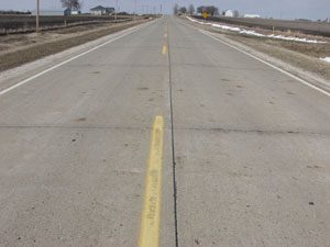
With an annual pavement marking program of approximately $2 million and another $750 thousand invested in maintenance of durable markings each year, the Iowa DOT is seeking every opportunity to provide all-year markings staying in acceptable condition under all weather conditions. The goal of this study is to analyze existing pavement marking practices and to develop a prototype Pavement Marking Management System (PMMS).
This report documents the first two phases of a three-phase research project. Phase I includes an overview of the Iowa DOT’s existing practices and a literature review regarding pavement marking practices in other states. Based on this information, a work plan was developed for Phases II and III of this study.
Phase II organized the key components necessary to develop a prototype PMMS for the Iowa DOT. The two primary components are (1) performance/life cycle curves for pavement marking products, and (2) an application matrix tailored to the pavement marking products and roadway and environmental conditions faced by the Iowa DOT. Both components will continue to be refined and tailored to Iowa materials and conditions as more performance data becomes available.
Funding Sources:
Midwest Transportation Consortium
Researchers
Tom Maze
Joshua Hochstein
Garrett Burchett
About the research
dministrative Final Rule CFR part 630 Subpart J ?Work Zone Safety and Mobility? requires that state transportation agencies (STAs) develop policies to investigate the safety and mobility impacts as early as possible in the project development process. The rule provides some flexibility by allowing each state to set its own procedures and policies to comply with the rule and by allowing states to seek solutions which are commensurate with the severity of the potential impacts and require the most aggressive planning for Significant Projects.
This report provides a synthesis of what is currently being done by STAs across the country to plan, manage, operate, and evaluate work zone safety and mobility. The research to develop this synthesis was broken into three distinct steps. The first step was to review the literature regarding work zone safety and mobility strategies. The second was to conduct interviews with staff members at 30 STAs. The last step was to conduct more detailed case studies of three STAs.
We found that only California and Ohio (there may be more states than this, but these were the two we discovered) had really thought about work zone impacts throughout the life-cycle of project development and project delivery and had documented the roles and interactions between different offices. Most agencies we interviewed lacked objective performance data, although many described processes where they have experts review and evaluate work zones on a periodic or continuous basis.
Funding Sources:
Iowa Department of Transportation ($25,000.00)
Midwest Transportation Consortium ($25,000.00)
Total: $50,000.00
Researchers
Ray Mundy
James F. Campbell
About the research
A system of 37 locks and dams has been constructed along the Upper Mississippi River and Illinois Waterway (UMR-IW) to provide reliable commercial inland navigation. This infrastructure has a limited throughput and delays at locks and dams create congestion, bottlenecks and inefficiencies at certain critical segments of the UMR-IW system. Over one million barge-hours are wasted annually waiting in these queues. These hours both decrease the total quantity of goods that can be moved, and increase the transportation costs of goods that are moved on the UMR-IW. This project will adopt a complementary approach that seeks to reduce congestion by employing an intelligent appointment system at the existing locks.
Funding Sources:
Midwest Transportation Consortium
Researchers
Tom Maze
Michael Crum
Garrett Burchett
About the research
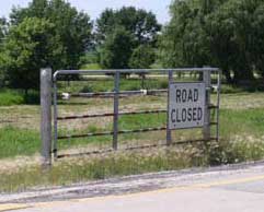
This project explores the user costs and benefits of winter road closures. Severe winter weather makes travel unsafe and dramatically increases crash rates. When conditions become unsafe due to winter weather, road closures should allow users to avoid crash costs and eliminate costs associated with rescuing stranded motorists. Therefore, the benefits of road closures are the avoided safety costs. The costs of road closures are the delays that are imposed on motorists and motor carriers who would have made the trip had the road not been closed. This project investigated the costs and benefits of road closures and found that evaluating the benefits and costs is not as simple as it appears.
To better understand the costs and benefits of road closures, the project investigates the literature, conducts interviews with shippers and motor carriers, and conducts case studies of road closures to determine what actually occurred on roadways during closures. The project also estimates a statistical model that relates weather severity to crash rates. Although, the statistical model is intended to illustrate the possibility to quantitatively relate measurable and predictable weather conditions to the safety performance of a roadway. In the future, weather conditions such as snow fall intensity, visibility, etc., can be used to make objective measures of the safety performance of a roadway rather than relying on subjective evaluations of field staff.
The review of the literature and the interviews clearly illustrate that not all delays (increased travel time) are valued the same. Expected delays (routine delays) are valued at the generalized costs (value of the driver?s time, fuel, insurance, wear and tear on the vehicle, etc.), but unexpected delays are valued much higher because they result in interruption of synchronous activities at the trip?s destination. To reduce the costs of delays resulting from road closures, public agencies should communicate as early as possible the likelihood of a road closure.
Funding Sources:
Iowa State University
Midwest Transportation Consortium ($58,591.00)
Total: $58,591.00
Researchers
Stephen Lamptey
About the research
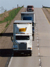
Reliable estimates of heavy-truck volumes are important in a number of transportation applications. Estimates of truck volumes are necessary for pavement design and pavement management. Truck volumes are important in traffic safety. The number of trucks on the road also influences roadway capacity and traffic operations. Additionally, heavy vehicles pollute at higher rates than passenger vehicles. Consequently, reliable estimates of heavy-truck vehicle miles traveled (VMT) are important in creating accurate inventories of on-road emissions.
This research evaluated three different methods to calculate heavy-truck annual average daily traffic (AADT) which can subsequently be used to estimate vehicle miles traveled (VMT). Traffic data from continuous count stations provided by the Iowa DOT were used to estimate AADT for two different truck groups (single-unit and multi-unit) using the three methods. The first method developed monthly and daily expansion factors for each truck group. The second and third methods created general expansion factors for all vehicles.
Accuracy of the three methods was compared using n-fold cross-validation. In n-fold cross-validation, data are split into n partitions, and data from the nth partition are used to validate the remaining data. A comparison of the accuracy of the three methods was made using the estimates of prediction error obtained from cross-validation. The prediction error was determined by averaging the squared error between the estimated AADT and the actual AADT.
Overall, the prediction error was the lowest for the method that developed expansion factors separately for the different truck groups for both single- and multi-unit trucks. This indicates that use of expansion factors specific to heavy trucks results in better estimates of AADT, and, subsequently, VMT, than using aggregate expansion factors and applying a percentage of trucks. Monthly, daily, and weekly traffic patterns were also evaluated. Significant variation exists in the temporal and seasonal patterns of heavy trucks as compared to passenger vehicles. This suggests that the use of aggregate expansion factors fails to adequately describe truck travel patterns.
Funding Sources:
Midwest Transportation Consortium ($119,500.00)
Total: $119,500.00
Researchers
Neal Hawkins
hawkins@iastate.edu email >Director Research Administration, ISU
About the research
This research project is aimed at development of an Iowa Pavement Markings Management System (PMMS). The project goal is to create a practical and useful management program specific to pavement markings for the Iowa Department of Transportation. This system will also be valuable to Iowa cities and counties for managing pavement marking resources.
Researchers
David Plazak
About the research
In most highway asset management exercises, real estate used in alignments is considered to be an asset class that does not depreciate. Although the treatment of right of way assets as non-depreciable real property may be appropriate as an accounting exercise, the fact is that the real estate contained in transportation corridors can in fact lose value from a traffic service point of view. Such facilities become functionally obsolete in that they no longer serve the purpose which was intended when they were planned, designed and built.
This report is intended to begin a discussion of the topic of how highway alignments ought be valued as assets as opposed to how they generally are valued, at either book value or replacement value, since it can be shown that some highway alignments do in fact depreciate in value.
Funding Sources:
Iowa Department of Transportation
Midwest Transportation Consortium
Project Details
01-98
07/01/01
10/31/03
Iowa Department of Transportation
Midwest Transportation Consortium
Researchers
Reginald Souleyrette
About the research
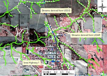
The main objective of the research was to evaluate the advanced remote sensing technology, LIDAR, as a method to provide the necessary data to support effective decision-making and resource allocation in asset management.
LIDAR technology integrated with airborne GPS and inertial measuring can allow surface measurements (x,y,z) with a typical vertical accuracy of 15cm. Further data processing can extract measurements of bare ground (removal of vegetation, snow cover, etc.); also, digital aerial photography can be obtained as LIDAR measurements are taken. For this project, LIDAR data were collected for two pilot study areas, assessed for accuracy and applicability relative to asset management data needs, and applied to three applications to evaluate practical use of the technology.
Three separate reports are available.
Funding Sources:
Iowa Department of Transportation ($70,000.00)
Midwest Transportation Consortium
Total: $70,000.00